Property Record
49 Kroeger Rd, Monticello, NY 12701
This Property Is For Sale
NEARBY LISTINGS FOR SALE OR LEASE
Property Detail
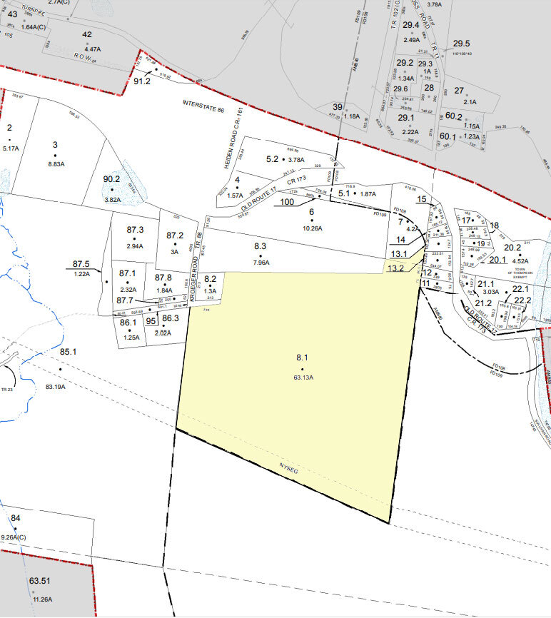
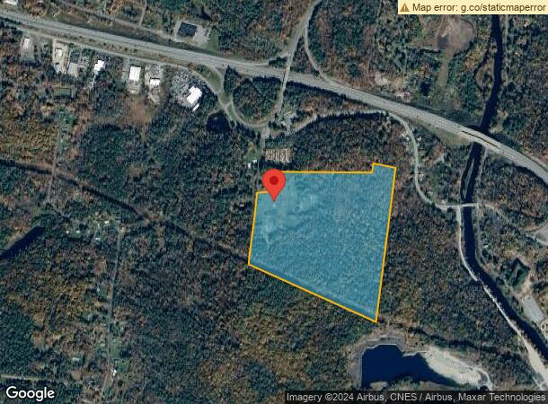
49 Kroeger Rd
Commercialacreage
Sullivan
X
New York
36105C0469F
8.001
2024
63.13 AC
2023
Hudson Valley Area
951701
Other Market Areas
35,520 SF
4689-032-0-0002-008-001
DEMOGRAPHICS near 49 Kroeger Rd
1 Mile
3 Mile
5 Mile
2024 Total Population
285
4,854
17,467
2029 Population
298
5,115
18,328
Pop Growth 2024-2029
+ 4.56%
+ 5.38%
+ 4.93%
Average Age
47
42
41
2024 Total Households
125
1,900
7,037
HH Growth 2024-2029
+ 4.80%
+ 5.58%
+ 5.19%
Median Household Inc
$79,808
$73,854
$52,038
Avg Household Size
2.20
2.40
2.40
2024 Avg HH Vehicles
2.00
2.00
2.00
Median Home Value
$241,666
$233,220
$210,182
Median Year Built
1971
1974
1974
Nearby Places
- Restaurants
- Banks
- Shops
- Fitness
- Groceries
PUBLIC TRANSPORTATION
AIRPORT
New York Stewart International
DRIVE
WALK
Distance
New York Stewart International
50 min
35.0 mi
Freight Ports
Port Newark Container Terminal
DRIVE
WALK
Distance
Port Newark Container Terminal
118 min
92.0 mi
Nearby Properties
Address
Land Use
TOTAL SIZE
Lot Size
Zoning
Address
Land Use
TOTAL SIZE
Lot Size
Zoning
1,777,903 SF
117.40 AC
PRD
Address
Land Use
TOTAL SIZE
Lot Size
Zoning
423,920 SF
131.50 AC
PRD
Address
Land Use
TOTAL SIZE
Lot Size
Zoning
3,123 SF
48.30 AC
RR
Address
Land Use
TOTAL SIZE
Lot Size
Zoning
80,736 SF
15.74 AC
PBP
Address
Land Use
TOTAL SIZE
Lot Size
Zoning
69,742 SF
21.63 AC
PRD
Address
Land Use
TOTAL SIZE
Lot Size
Zoning
3,699 SF
334.81 AC
PUD #6
Address
Land Use
TOTAL SIZE
Lot Size
Zoning
194,704 SF
30.90 AC
HC1
Address
Land Use
TOTAL SIZE
Lot Size
Zoning
648 SF
74.20 AC
RR
Address
Land Use
TOTAL SIZE
Lot Size
Zoning
600 SF
14.92 AC
SR
Address
Land Use
TOTAL SIZE
Lot Size
Zoning
6,042 SF
12.38 AC
EBG
Address
Land Use
TOTAL SIZE
Lot Size
Zoning
82,342 SF
13.65 AC
HC2
Address
Land Use
TOTAL SIZE
Lot Size
Zoning
55,365 SF
11.85 AC
HC2
Address
Land Use
TOTAL SIZE
Lot Size
Zoning
31,704 SF
98.90 AC
RR1
Address
Land Use
TOTAL SIZE
Lot Size
Zoning
52,290 SF
26.40 AC
RM
Address
Land Use
TOTAL SIZE
Lot Size
Zoning
28,392 SF
8.40 AC
RM
Address
Land Use
TOTAL SIZE
Lot Size
Zoning
5,627 SF
10.05 AC
SR
Address
Land Use
TOTAL SIZE
Lot Size
Zoning
29,320 SF
9.31 AC
HC2
Address
Land Use
TOTAL SIZE
Lot Size
Zoning
59,120 SF
7.30 AC
EBV
Address
Land Use
TOTAL SIZE
Lot Size
Zoning
2,400 SF
1,079.65 AC
E
Address
Land Use
TOTAL SIZE
Lot Size
Zoning
14,689 SF
7.71 AC
RM
Address
Land Use
TOTAL SIZE
Lot Size
Zoning
2,244 SF
141.85 AC
RR1
Address
Land Use
TOTAL SIZE
Lot Size
Zoning
672 SF
172.91 AC
EBG
Address
Land Use
TOTAL SIZE
Lot Size
Zoning
26,000 SF
13.30 AC
EBG
Address
Land Use
TOTAL SIZE
Lot Size
Zoning
28,216 SF
3.09 AC
RM
Address
Land Use
TOTAL SIZE
Lot Size
Zoning
6,123 SF
1.26 AC
R2
Address
Land Use
TOTAL SIZE
Lot Size
Zoning
22,540 SF
3.43 AC
EBG
Address
Land Use
TOTAL SIZE
Lot Size
Zoning
964 SF
152.05 AC
HC2
Address
Land Use
TOTAL SIZE
Lot Size
Zoning
13,456 SF
5.41 AC
SR
Address
Land Use
TOTAL SIZE
Lot Size
Zoning
27,810 SF
4.47 AC
CI
Address
Land Use
TOTAL SIZE
Lot Size
Zoning
10,060 SF
1.38 AC
EBV
The World's #1 Commercial Real Estate Marketplace
Connect with us
© 2025 CoStar Group
The information above has been obtained from sources believed reliable. While we do not doubt its accuracy we have not verified it and make no guarantee, warranty or representation about it. It is your responsibility to independently confirm its accuracy and completeness. Any projections, opinions, assumptions, or estimates used are for example only and do not represent the current or future performance of the property. The value of this transaction to you depends on tax and other factors which should be evaluated by your tax, financial, and legal advisors. You and your advisors should conduct a careful, independent investigation of the property to determine to your satisfaction the suitability of the property for your needs.